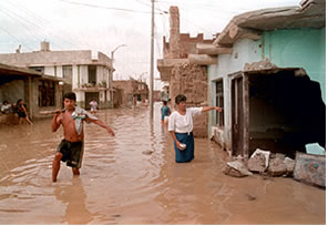
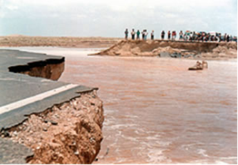
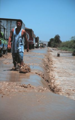
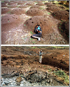
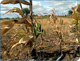
El Niño and La Niña -- the Pacific’s deadly duo
Continued from previous page
(c) 1999 World Disaster Report
International Federation of Red Cross and Red Crescent Societies
www.ifrc.com
All rights reserved.
next >

1   2   3  Sources


Crowded coasts court disaster

The impact of El Niño is made worse by urban development and corresponding
population shifts. Peru’s capital, Lima, is home to 8.5 million people --
compared to just 1.8 million in 1970. Of Peru’s 24 million residents, 73 percent
live within 80 kilometers of the sea, up sharply from 54 percent three decades
ago. That shift is partly due to the activities of Maoist Shining Path rebels and
the pro-Cuban Tupac revolutionary Movement (MRTA), which, from 1980
onwards, drove farmers out of the provinces to coastal areas (especially Lima)
where army protection was more effective.

Poverty pushes people into urban and coastal areas where jobs are centralized.
All four countries making up the Pacific coast of South America (Chile, Peru,
Ecuador and Colombia) have seen their population concentrate in coastal areas,
in part because of the inhospitable environment of the Andes Mountains and the
Amazon jungle. Modern Latin Americans may not be as in tune with nature as
their Inca predecessors, who built their cities on hilltops or away from rivers to
escape the landslides and floods, which have afflicted this land for thousands of years.

Weak infrastructure, common to most poor countries, further aggravates the effects of El Niño. According to a 1996 expose in the news
magazine Si, modern Peruvian highways are built under government regulations that require only a one-centimetre base and eight
centimetres of pavement. That compares to an average 22 centimetres of pavement and base in the US and 24 centimetres in most of
Western Europe. Bridges, sewer systems, embankments, and other key structures are built to similarly poor standards, often due to
lack of funds.


Pandolfi added that future government responses would reflect what was learned during the most recent disaster. "It was a positive
step not to attempt to run anti-disaster efforts from Lima," he said, "and rebuild infrastructure will be to a higher standard more ready to
stand up to a future disaster." On the use of early warning systems, he said: "Given the technology of this era, basing preparations on
what has happened in the past is inadequate. There are methods we should employ that will give us a more accurate image of what is
ahead."

In addition to Peru, other countries in the region affected by El Niño and La Niña included:


El Niño’s Latin American legacy has not, however, been all doom and gloom. Some consumer product sectors benefited from the
unusually warm weather, with beer and ice cream sales surging over 20 percent in Peru during winter 1997, compared to the same
period in 1996. In Ecuador, beverage sales in 1997 were 15 percent higher than in 1996. And the rains in northern Peru and southern
Ecuador watered a normally infertile desert, creating a lake locals named La Niña, 300 kilometres long, 40 kilometres wide and 10
meters deep. The lake stimulated tourism in the area and has even been stocked with fish, to be harvested until the waters dry up in
two to three years. The lake also created thousands of hectares of farmland, much of which will remain fertile for a decade or more.
And El Niño-inspired research into more sophisticated early warning systems will help better predict the severity and timing of other
perennial weather patterns.

Parched paradise in the Pacific

While El Niño drenched Latin America with unseasonal rains, the south-west Pacific
sweltered under cloudless skies. Covering more than a third of the entire planet’s
surface, the pacific Ocean is a "continent of water" up to 16,000 kilometres wide
and home to around 30,000 islands and coral atolls. Many are threatened by
sea-level-rise, resulting from the so-called "greenhouse effect." which is eroding
coastlines, encroaching on arable land, and infiltrating groundwater supplies.

As west-blowing trade winds weakened and atmospheric pressure decreased
over the central Pacific, warm seas and rain-clouds moved east, radically reducing
precipitation levels in the southwest Pacific. Droughts blighted many countries in
the region including Australia, Indonesia, New Zealand, Papua New Guinea, Fiji,
and the Solomon Islands, hitting hard states that rely on arable crops for domestic
consumption and export revenue.

The islands states of the southwest Pacific range in size from the largest,
Papua New Guinea, down to Tokelau, covering just 12 square kilometers. With
small economies based mostly on fishing and the export of coffee, tea, cocoa,
sugar, and exotic timber, these island states are highly vulnerable to the
unpredictable fluctuations of global markets and climate alike. In an attempt to
raise export levels, local food production has suffered, increasing imports of
processed food and pushing up costs. The islands’ economies are enormously
fragile and, with El Niño threatening to shatter them, are increasingly sustained
through injections of foreign aid.

Some 84 percent of people in the Solomon Islands live in rural areas at a subsistence level, surviving in traditional crops of root
vegetables and fruit. Extra food is provided by pigs, chickens (which also generate cash income) and, more importantly, fishing. But
most people rely heavily on the garden cultivation of kumara (sweet potato), yams, taro, pana (prickly yarm), pawpaws, and bananas.

Throughout 1998, the Solomon Islands experienced significantly reduced rainfall, causing widespread and severe draught. A typical
casualty was Basakana Island off the northern tip of Malaita, one of the Solomon’s six major island provinces. Bakasana is just two
kilometers long and one kilometer wide -- its white sand beaches and coral reef seem the archetypal vision of a tropical island
paradise. Along with most other Solomon islanders, Bakasana’s 380 inhabitants survive on what they can grow and harvest from the
sea.

The failure of staple crops (potato and taro) planted in February and March led to a severe food shortage on the island. The
government, along with non-governmental organizations (NGOs) and the Catholic Church, had to initiate a supplementary feeding
programme until the next harvest, in order to maintain nutrition levels, especially among children.

Rougher-than-normal-seas, whipped up by changing climatic conditions, have added to islanders’ woes by limiting coastal fishing
activities and restricting access to "main island" markets.

Further to the east, Fiji -- the largest state in the southwest Pacific after Papua New Guinea -- has also borne the effects of an
unusually severe El Niño weather pattern. Like other pacific island nations, Fiji’s economy is largely agrarian, with subsistence
farming at village level still the primary means of livelihood. Tourism and sugar exports account for most foreign earnings.

About 270,000 people, roughly a third of the population, have been affected by the 1998 drought. Across half the island no significant
rain fell over seven months. Many of the affected people rely almost entirely on harvesting sugar cane for their livelihood. Small-scale
farmers, cane cutters and labourers, who under normal circumstances live just above the poverty line, have been badly hit, with 50
percent of the year’s crop decimated by drought. The resultant huge drop in income for these people has rendered them completely
reliant to others.

The government of Fiji, already in severe financial difficulties, is finding it hard to cope. Support has come from, among others, the Red
Cross/ Red Crescent and the US and Japanese governments. This will continue for the foreseeable future until crops have been re-
established.

Fire and frost in Papua New Guinea

Papua New Guinea features some of the most rugged terrain on earth. Its widely dispersed population lives in often very isolated
communities and speaks over 700 languages and dialects. A land of earthquakes, volcanoes, floods and mudslides, Papua is no
stranger to disaster. But, with the notable exception of a devastating tsunami in July 1998, events in this part of the globe do not
command worldwide attention.


In February, rain returned and in many areas farmers began replanting the staple sweet potato. But this is a slow-maturing crop, so
supplementary food supplies had to continue, as did distribution of seeds and seedlings more resistant to frost and drought.

A common thread runs through Pacific island nations: they are small and cut-off, with fragile, undiversified economies and
populations, which rely largely on fishing and subsistence agriculture for their livelihoods. Small-scale market gardening of crops like
taro, sweet potato and yams, combined with fishing, is pivotal to the existence of most inhabitants.

El Niño has had a profound effect on these communities. Drought has led to severe crop failures among peoples with very few
alternatives to their subsistence lifestyle. Add to this the localized effects of frosts and adverse sea conditions and the past 12 months
have wrought considerable suffering.

In the past, traditional cropping methods have coped, more or less, with El Niño. But the 1997-98 event was particularly severe,
pointing way for a dramatic rethink of agricultural practices in this part of Oceania. Diversification of crops, however, cannot be achieved
by Pacific states alone. Most rely heavily on foreign aid and cannot by themselves sustain their citizens when times are hard. The
goodwill of developed countries is needed to provide the finance, and in some cases the expertise, to help establish El Niño-proof
systems of agriculture able to cope with accelerating climatic changes. For the southwest Pacific, the El Niño of 1997-98 has served
as a warning and one that must be heeded if similar consequences are to be avoided in the future.